![](/images/other/stat-length.png)
![Excursión La Giettaz - Les Chapets - Photo](https://media.geolcdn.com/t/1900/400/ext.pjpeg?maxdim=2&url=https%3A%2F%2Fsecurestorage.geolives.com%2Fsitytour%2Ftrail-bg%2Fdefault.jpg)
Les Chapets
olivieraron
Usuario
![Longitud](/images/other/stat-length.png)
![Altitud máxima](https://static1.geolcdn.com/siteimages/upload/files/1508320355ic_sort_altitude_max_24dp.png)
![Desnivel positivo](https://static1.geolcdn.com/siteimages/upload/files/1508320355ic_sort_den_pos_24dp.png)
![Km-Effort](/images/other/stat-length.png)
![Altitud mínima](https://static1.geolcdn.com/siteimages/upload/files/1508320355ic_sort_altitude_min_24dp.png)
![Desnivel negativo](https://static1.geolcdn.com/siteimages/upload/files/1508320355ic_sort_den_neg_24dp.png)
![Boucle](https://static1.geolcdn.com/siteimages/upload/files/16400158638029165_repeat_loop_refresh_sync_direction_icon.png)
![Escanee este código QR para abrir la excursión en la aplicación SityTrail](https://capi.geolives.com/qq0zvz2zws4bq2lad0pu/sitytour/trails/3571134/qr.png?size=200)
Aplicación GPS de excursión GRATIS
A propósito
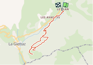
Ruta de 8,4 km a descubrir en Auvergne-Rhône-Alpes, Saboya, La Giettaz. Esta ruta ha sido propuesta por olivieraron.
Descripción
Suivre le balisage TSL rose
Depuis le parking du Plan, emprunter le chemin damé qui longe le torrent l'Arrondine en cheminant à proximité de l'espace de luge. Poursuivre sur un chemin forestier en direction des Chapets en passant par l'Armoy et les Arsets. A ce carrefour prendre à gauche pour rejoindre les Quatre chemins, puis les chalets des Chapets. Après avoir admiré le panorama sur la vallée, revenir au carrefour des quatre chemins, puis prendre à droite la piste qui se faufile entre les arbres. Les plus courageaux pourront faire un aller retour jusqu'au Boeu du Chapet, les autres continueront tout droit sur le chemin du Golet et redecendrons pour rejoindre le circhuit de montée des Arsets.
Le retour au Plan s'effectue par le même itinéraire qu'à l'aller.
Localización
Comentarios
Excursiones cerca
![Excursión Senderismo La Giettaz - Le Plan - col de Jaillet - Photo](https://media.geolcdn.com/t/375/260/ext.jpg?maxdim=2&url=https%3A%2F%2Fservices.sitytrail.com%2FGeolivesWS%2FDownloadMedia.ashx%3FTrailID%3D333788%26Media%3D20140812144015.jpg)
![Senderismo Senderismo](https://static1.geolcdn.com/sitytour/trail-icons/101.png)
Senderismo
![](/images/other/stat-length.png)
![](https://static1.geolcdn.com/siteimages/upload/files/16400158638029165_repeat_loop_refresh_sync_direction_icon.png)
![Excursión Senderismo La Clusaz - 74.trou de la mouche la Clusaz août 2022 - Photo](https://media.geolcdn.com/t/375/260/013ecbc8-ff05-411a-964c-f1dce6454639.jpg&format=jpg&maxdim=2)
![Senderismo Senderismo](https://static1.geolcdn.com/sitytour/trail-icons/101.png)
Senderismo
![](/images/other/stat-length.png)
![](https://static1.geolcdn.com/siteimages/upload/files/16400158638029165_repeat_loop_refresh_sync_direction_icon.png)
![Excursión Esquí de fondo Praz-sur-Arly - Tête du Torraz - Photo](https://media.geolcdn.com/t/375/260/24f78c03-38ed-430b-939f-d7ada4ba5583.jpg&format=jpg&maxdim=2)
![Esquí de fondo Esquí de fondo](https://static1.geolcdn.com/sitytour/trail-icons/503.png)
Esquí de fondo
![](/images/other/stat-length.png)
![](https://static1.geolcdn.com/siteimages/upload/files/16400158638029165_repeat_loop_refresh_sync_direction_icon.png)
![Excursión Senderismo La Giettaz - Boucle de Croisse Baulet - Photo](https://media.geolcdn.com/t/375/260/ext.jpg?maxdim=2&url=https%3A%2F%2Fservices.sitytrail.com%2FGeolivesWS%2FDownloadMedia.ashx%3FTrailID%3D1073387%26Media%3Dfix__20181118125800.jpg)
![Senderismo Senderismo](https://static1.geolcdn.com/sitytour/trail-icons/101.png)
Senderismo
![](/images/other/stat-length.png)
![](https://static1.geolcdn.com/siteimages/upload/files/16400158638029165_repeat_loop_refresh_sync_direction_icon.png)
![Excursión Raquetas de nieve La Clusaz - col aravis - Photo](https://media.geolcdn.com/t/375/260/ext.jpg?maxdim=2&url=https%3A%2F%2Fservices.sitytrail.com%2FGeolivesWS%2FDownloadMedia.ashx%3FTrailID%3D926860%26Media%3Dfix__20180314155607.jpg)
![Raquetas de nieve Raquetas de nieve](https://static1.geolcdn.com/sitytour/trail-icons/504.png)
Raquetas de nieve
![](/images/other/stat-length.png)
![](https://static1.geolcdn.com/siteimages/upload/files/16400158638029165_repeat_loop_refresh_sync_direction_icon.png)
![Excursión Senderismo La Clusaz - confins - Trou de la mouche - Photo](https://media.geolcdn.com/t/375/260/ext.jpg?maxdim=2&url=https%3A%2F%2Fservices.sitytrail.com%2FGeolivesWS%2FDownloadMedia.ashx%3FTrailID%3D649324%26Media%3De8817909-efba-47ef-85a6-4fb05f5f6537.JPG)
![Senderismo Senderismo](https://static1.geolcdn.com/sitytour/trail-icons/101.png)
Senderismo
![](/images/other/stat-length.png)
![](https://static1.geolcdn.com/siteimages/upload/files/16400158638029165_repeat_loop_refresh_sync_direction_icon.png)
![Excursión Otra actividad La Giettaz - croise baulet - Photo](https://media.geolcdn.com/t/375/260/ext.jpg?maxdim=2&url=https%3A%2F%2Fstatic1.geolcdn.com%2Fsiteimages%2Fupload%2Ffiles%2F1545311037marcheuse_200dpi.jpg)
![Otra actividad Otra actividad](https://static1.geolcdn.com/sitytour/trail-icons/900.png)
Otra actividad
![](/images/other/stat-length.png)
![](https://static1.geolcdn.com/siteimages/upload/files/16400158638029165_repeat_loop_refresh_sync_direction_icon.png)
![Excursión Motor La Giettaz - La Giettaz - Col des Aravis - Photo](https://media.geolcdn.com/t/375/260/ext.jpg?maxdim=2&url=https%3A%2F%2Fstatic1.geolcdn.com%2Fsiteimages%2Fupload%2Ffiles%2F15247431544x4.jpg)
![Motor Motor](https://static1.geolcdn.com/sitytour/trail-icons/400.png)
Motor
![](/images/other/stat-length.png)
![](https://static1.geolcdn.com/siteimages/upload/files/16400158638029165_repeat_loop_refresh_sync_direction_icon.png)
![Excursión Senderismo La Clusaz - la grande combe de la forclaz - Photo](https://media.geolcdn.com/t/375/260/005f15ae-5a7c-4772-a280-40716eaf9244.jpg&format=jpg&maxdim=2)
![Senderismo Senderismo](https://static1.geolcdn.com/sitytour/trail-icons/101.png)
Senderismo
![](/images/other/stat-length.png)
![](https://static1.geolcdn.com/siteimages/upload/files/16400158638029165_repeat_loop_refresh_sync_direction_icon.png)